Surveying has been an essential part of construction, land management, and mapping for centuries. It provides the foundation for designing and implementing projects such as roads, bridges, buildings, and more. Surveying instruments play a crucial role in ensuring the accuracy and precision of measurements during land surveys. Whether you’re a professional surveyor or someone interested in the field, understanding the tools of the trade is important. In this blog post, we will explore the different types of surveying instruments, their uses, and their significance in achieving accurate and reliable results.
1. The Importance of Surveying Instruments
Surveying instruments are designed to measure distances, angles, elevations, and locations with high precision. Accurate measurements are vital for the success of construction projects, land subdivisions, and the preparation of topographic maps. The choice of instrument depends on the type of survey being conducted, the environment, and the required level of precision.
2. Types of Surveying Instruments
There are several types of surveying instruments, each suited for specific tasks. Here’s a rundown of the most commonly used tools in the field:
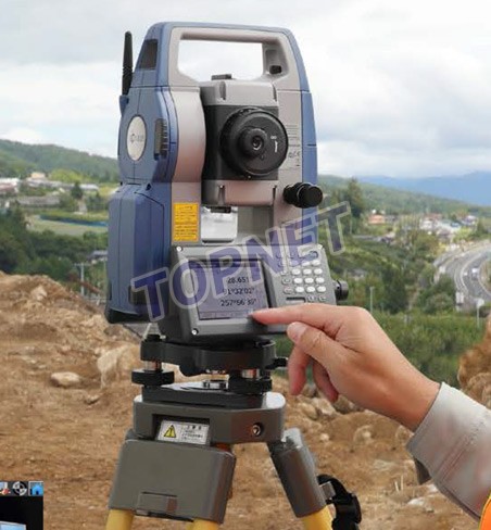
A. Total Station
A total station is a modern electronic device that combines an electronic theodolite with an electronic distance measuring (EDM) device. It is used to measure angles and distances simultaneously, and it can store data digitally for easy analysis and reporting.
- Applications: Land surveying, construction, and geodetic measurements.
- Advantages: High accuracy, digital data storage, and the ability to measure both horizontal and vertical angles.
B. Theodolite
The theodolite is one of the oldest instruments still used in surveying today. It is primarily used to measure horizontal and vertical angles. Though less common in modern surveys due to advancements like the total station, the theodolite is still relied upon for certain types of work.
- Applications: Angle measurement, setting out of reference points, and aligning structures.
- Advantages: High precision, simple operation, and reliability.
C. GPS Surveying (Global Positioning System)
GPS technology has revolutionized surveying by providing real-time location data with global accuracy. Surveying with GPS involves the use of satellites to determine precise coordinates (latitude, longitude, and elevation) anywhere on Earth.
- Applications: Geodetic surveys, boundary surveys, mapping large areas, and navigation.
- Advantages: Can be used in remote locations, offers high accuracy, and reduces the need for physical markers.
D. Level (Optical Level and Digital Level)
Levels are used to measure differences in elevation. The optical level uses a sighting scope to align with a level staff at a known reference point, while digital levels provide more advanced functionality and accuracy through electronic reading.
- Applications: Construction, grading, and determining elevation differences.
- Advantages: High accuracy in measuring vertical distances, simple to operate.
E. Chain and Tape Measures
The chain (or Gunter’s chain) and tape measure are simple yet effective tools for measuring distance. The chain is typically used in land surveying, especially for longer distances, while the tape measure is more commonly used for shorter distances.
- Applications: Measuring land parcels, distances for construction.
- Advantages: Simple, cost-effective, and portable.
F. Prism and Rod
Prisms and rods are often used in conjunction with total stations or electronic distance meters (EDMs) to reflect light signals back to the instrument, aiding in accurate distance measurement.
- Applications: Distance measurement and setting reference points in land surveys.
- Advantages: Lightweight, easy to use with electronic instruments.
3. How Surveying Instruments Are Used
Surveying instruments are employed in various stages of a project, from initial planning to final construction. Here’s a breakdown of how these tools are used in typical surveying tasks:
- Boundary Surveys: Determining property lines and boundaries. Instruments like the total station and GPS are commonly used for these types of surveys.
- Topographic Surveys: Creating detailed maps of land contours and features. Instruments such as the total station, theodolite, and levels are often used to collect the data.
- Construction Surveys: Establishing reference points, aligning roads, buildings, or other structures. The use of total stations, levels, and GPS ensures that the construction follows precise design plans.
- Geodetic Surveys: Measuring large-scale land areas or the shape of the Earth. GPS surveying and other advanced instruments are used to provide global accuracy.
4. Advancements in Surveying Instruments
Over the years, technological advancements have dramatically improved the accuracy, ease of use, and versatility of surveying instruments. Some notable innovations include:
- Robotic Total Stations: These systems allow surveyors to control the instrument remotely, reducing labor and increasing efficiency.
- LiDAR (Light Detection and Ranging): This technology uses laser scanning to generate highly accurate 3D representations of landscapes or structures.
- Mobile Mapping Systems: Using GPS and LiDAR, these systems capture large amounts of data on the go, making surveys faster and more comprehensive.
- Drones: Drones equipped with cameras and LiDAR sensors can be used for aerial surveying, providing detailed images and data for topographic surveys and mapping.
5. Choosing the Right Surveying Instrument
When selecting a surveying instrument, it’s important to consider the type of survey being conducted, the level of precision required, the terrain, and the environment. For instance, if you’re working in an open area with clear visibility, GPS-based instruments may be ideal. However, in areas with obstructed views, such as urban settings or dense forests, instruments like total stations or theodolites may be more practical.
6. Maintaining Surveying Instruments
To ensure continued accuracy and longevity, regular calibration and maintenance of surveying instruments are essential. Here are a few tips:
- Keep instruments clean and free from dust or debris.
- Store instruments in protective cases when not in use.
- Calibrate instruments regularly, especially after extensive use or exposure to harsh conditions.
- Follow manufacturer guidelines for maintenance and service.
Conclusion
Surveying instruments are indispensable tools in the field of land surveying, construction, and mapping. From basic tools like tape measures to advanced systems like robotic total stations and GPS, these instruments allow professionals to measure, record, and analyze data with exceptional precision. As technology continues to advance, the future of surveying looks even more exciting, with innovations like drones and LiDAR reshaping the way we map and measure the world.
If you’re a surveyor, engineer, or architect, investing in the right tools is essential for the success of your projects. Always ensure that your instruments are properly maintained and calibrated for optimal performance. With the right surveying instruments, you can confidently tackle any surveying task, large or small.